
Finding Hillforts
How do we know where hillforts are? Some hillforts are very visible on the ground: their huge ramparts and ditches are hard to miss. Others are harder to spot. They might be hidden deep within trees, or obscured by bracken and other vegetation. Some have been all but obliterated by later land-use. However, they aren’t necessarily lost to us forever.
Aerial photography
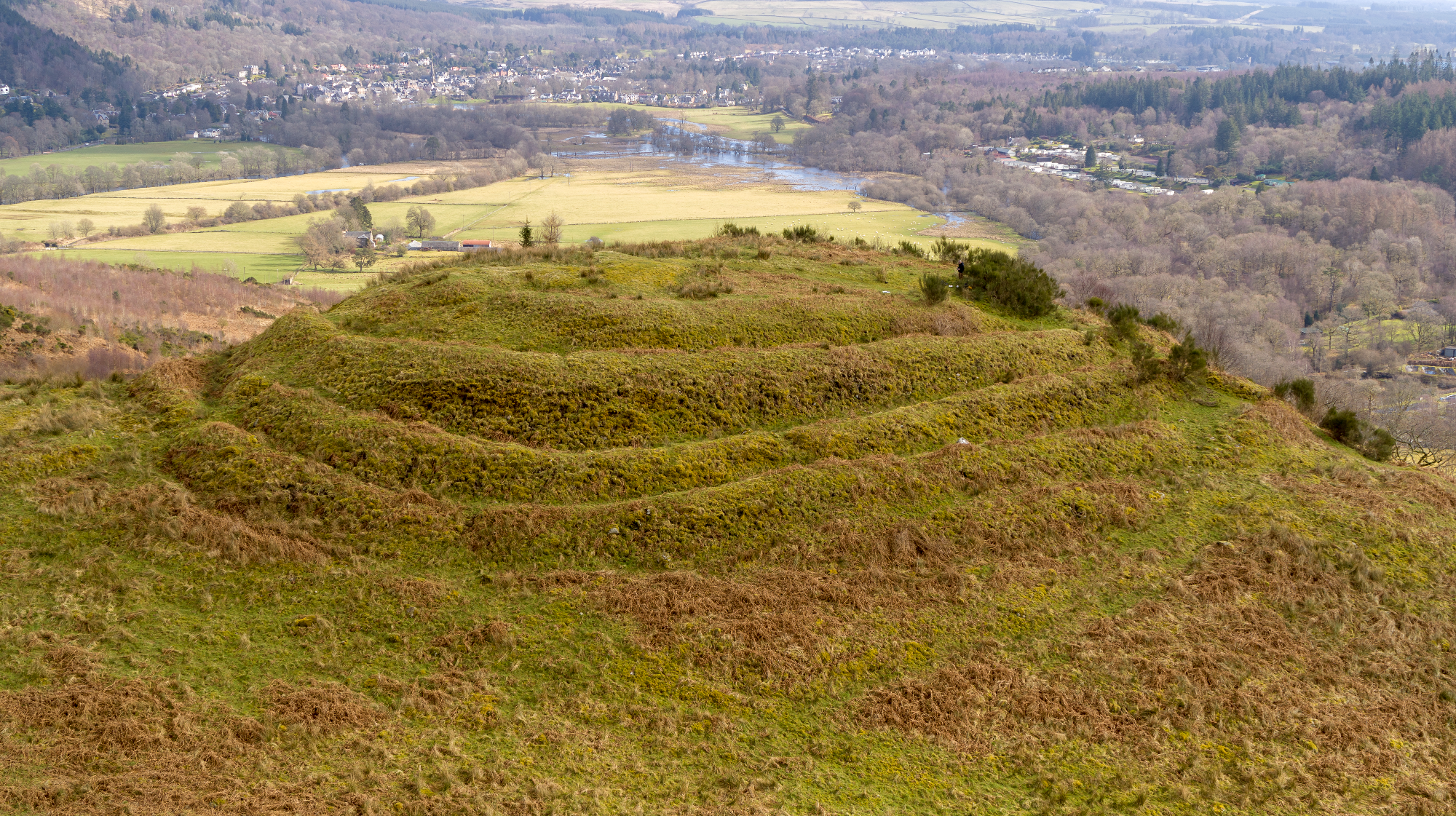
Dunmore looks dramatic viewed from the air
Photo © Historic Environment Scotland
Photographs taken from low flying light aircraft can reveal sites not previously identified. During the second world war, huge aerial photography surveys were undertaken in the interests of reconnaissance. In the years that followed, these photographs proved to be a valuable resource in the identified of previously unnoticed archaeological sites. Photographs taken close to dawn or dusk, when the sun is lower and shadows are longer, can reveal slight features that might otherwise be missed. Similarly, a light dusting of snow can reveal long-lost archaeology since the snow will last longest in slight hollows and dips that don’t get much sunlight.
Crop Marks

Easter Torrie is visible from the air as a crop mark. Can you make out the sweeping curve of the ditch, which shows up a little darker, with pale lines showing the lines of the ramparts?
Image: Maxar, Microsoft
In some cases, enclosed settlements have been ploughed over so many times that they are all but invisible on the surface. However, that doesn’t mean that they are lost entirely. Deep beneath the ground, the infilled ditches will hold more water than the more densely packed ground around them. Their fills will be looser and will provide a more fertile environment, meaning that any grass or crops growing there will ripen more quickly than the surrounding plants. Walls or similarly dense features give crops/grass less fertile ground in which to put down their roots, resulting in slower ripening/stunted growth of crops. In grass, dense features can show as parch marks where the ground dries out more quickly in summer. These circumstances make the invisible visible again – from the air, at least.

The King’s Knot, Stirling: was it built over an Iron Age enclosed site?
Photo © Graham Hogg (cc-by-sa/2.0)
The King's Knot, part of the formal gardens associated with Stirling Castle, appears to have built over what was once an enclosed site. The remains of three ditches have been identified through parch marks in the grass. It is not surprising that an abandoned enclosed settlement (if that is what it was) was scrubbed out to make way for a garden fit for a king. The ruinous ditches and ramparts might have been quite an eyesore!
Finding Hillforts Near You
Hillforts are all around us. You might have been to one without ever knowing it! There are lots of ways to find and identify hillforts in your area. Here are some of the simplest methods.
Printed Maps

Image by Annie Spratt on Unsplash
Hillforts (and all sorts of other archaeological sites) are shown on maps such as OS Explorer maps, which are used by hillwalkers. You’ll see hillforts marked by name, with lines marking the ramparts.
Paper maps can be useful in teaching concepts such as scale and compass direction. For example, encourage your learners to work out the distance between the school and lots nearest hillfort by measuring the distance with a ruler, and using the scale to work out how far that is in metres/kilometres. The Ordnance Survey has resources for teaching available here.
Atlas of Hillforts

The Atlas of Hillforts is a fabulous resource that maps and describes every known or possible hillfort in Britain and Ireland.
The simplest way to find hillforts near you is to zoom in on your local area. You can see the Callander area shown above; forts are marked with orange dots. Alternatively, you can use the ‘Query’ function to select a geographical location and limit the results to those in your area. Full instructions are provided in the ‘Mapping Hillforts’ activity.
Canmore

You can identify hillforts in Canmore using the search facility.
Go to ‘advanced search’ and under ‘classification’, put in FORT. This will bring up a list of sites that are classified as forts. Toggle to the map tab (below) and zoom in on your area to find your nearest hillforts. Click on the blue dots to read more about any site.
Satellite Imagery
Keep an eye out when using maps on your smartphone to get about - if you toggle to the satellite imagery option, you might just spot a hillfort!
Dunmore is shown here as it appears in Google Maps. Less well known or accessible sites won’t be marked like this, but their ramparts and ditches might be visible. Look for concentric circles forming an enclosure.